David A. King
Have you ever prayed in the qibla? If not, then you know nothing about the qibla.
Question from a Muslim dignitary after a lecture of mine Istanbul in July, 1983, on the newly-discovered sources relating to the sacred geography of Islam.
The sacred direction in Islam is called qibla in all of the languages of the Islamic common-wealth. The direction may be defined towards the sacred Kaʿba itself or towards the city of Mecca. As we shall see, there is a substantial difference in the ways in which these two concepts were addressed, by the legal scholars on the one hand and by the astronomers on the other.
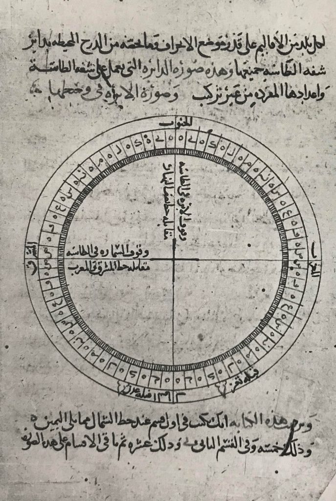
Europeans were interested in Islamic geography already in the 16th century. Both Jean Chardin and Jean-Baptiste Tavernier, who visited Iran in the 17th century, recorded longitudes and latitudes of places they visited, relying, inevitably, on local informants. The geographical tables of Abu ʾl-Fidāʾ, Naṣīr al-Dīn al-Ṭūsī and Ulugh Beg were published in Oxford about the same time (1712) as ʿAbd al-ʿAlī was making his astrolabe for the Safavid Shāh Ḥusayn.1 In 18th-century Europe, the three most popular Arabic works in translation were the Qurʾān, the Thousand and One Nights, and Abu ʾl-Fidāʾ’s Geography in its several variants.2 But this interest waned in the 19th century, despite the fact that by then various other medieval texts had been published. Now it was also in the 19th century that European orientalists began to be interested in the systematic study of Arabic and Persian astronomical texts that were not transmitted to Europe – the Sédillots père et fils in Paris with their publications on the treatise on astronomical instruments by Abū-ʿAlī al-Marrākushī and the astronomical handbook of Ulugh Beg are the most outstanding examples. In each of these works there are extensive geographical tables and discussions of the determination of the qibla. The Polish historian Joachim Lelewel in his Géographie du moyen âge (1850-57) was the first (and last) to consider what maps based on these and other medieval Islamic geographical tables would look like. His reconstructions have been ignored by later historians because no original maps of this kind exist. But now, given the evidence that such maps were indeed made in the middle Ages, Lelewel’s reconstructions assume a new importance.3
Our knowledge of Muslim interest over the centuries in the determination of the qibla has increased in leaps and bounds in recent decades. By medieval standards, the problem of the determination of the direction of one place to another is a non-trivial problem of applied mathematics, and the solutions developed by Muslim scientists are of paramount interest for the history of Islamic mathematics. But the treatment of the qibla problem by Muslim scholars, competent mathematicians and mathematical innocents alike, goes far beyond the history of science, and indeed it constitutes one of the most interesting chapters in the history of Islamic civilization. In the 19th century virtually no medieval texts on the qibla had been studied (the main exceptions are the treatments of the subject by al-Marrākushī and Ulugh Beg). As a result, on the one hand, the determination of the qibla is invariably not mentioned in modern popular accounts of Islamic science; these show a depressing tendency to repeat the platitudes of earlier writings and hence to omit much of the new material discovered during the past 50 years. On the other hand, modern works on historical religious architecture in the Islamic world tend to assume that this architecture should be oriented more or less in a direction corresponding to the modern qibla, and their authors occasionally observe that sometimes this architecture is not correctly Mecca-oriented. Such assertions stem from ill-founded notions of what is correct.
The first serious analysis of medieval qibla-determinations was conducted by the German historian of Islamic science Carl Schoy in the early decades of this century. He published the procedures of such scholars as al-Nayrīzī, Ibn Yūnus, Ibn al-Haytham and al-Bīrūnī, and he authored the article “Ḳiblaˮ in the first edition of the Encyclopaedia of Islam. He also investigated the mathematical mapping – it is cartographic but it is not a ‘projection’ – which would preserve direction and distance to Mecca at the center. Schoy did this out of sheer enthusiasm, not because he had any inkling that Muslims had actually made world-maps of this kind.
The American scholar Edward S. Kennedy continued these investigations in the 1960s and ’70s, publishing the qibla-procedure of Ḥabash al-Ḥāsib as well as the monumental treatise on mathematical geography by al-Bīrūnī, whose ultimate purpose was to calculate the qibla at Ghazna (in what is now Afghanistan). This remarkable book is the most detailed and the richest work on mathematical geography known from the Middle Ages. To Ted Kennedy and his former Lebanese colleague Fuad Haddad and later to his wife Mary-Helen goes our gratitude firstly for realizing the importance of the geographical data recorded in over 100 medieval Islamic sources, and secondly for publishing this data in an easily usable (if not easily accessible) from. The present study would have involved double the work had I not had access to their published data-base of medieval Islamic geographical coordinates. Again that publication has not yet been taken seriously by historians of cartography because no examples of maps based on such tables survive (at least so we thought until 1989).
My own investigations of the qibla problem started in the 1970s and resulted in the discovery of various medieval tables displaying the qibla as a function of terrestrial longitude and latitude. The state of our knowledge around 1980 is summarized in my article “Ḳiblaˮ in the new edition of the Encyclopaedia of Islam. Somehow there was something very fascinating about writing on the practical applications of science for religious purposes. In that article I remarked in passing that the orientation of medieval mosques often does not correspond to what one would expect in the light of medieval mathematical geography, but I confess that at the time I did not know why.
In the 1980s I identified numerous previously unstudied works in which the qibla is treated in terms of folk astronomy, that is, not in mathematical terms. According to these works the qibla is to be found using astronomical horizon phenomena (risings and settings of the sun and various bright stars). The Kaʿba in Mecca is itself astronomically aligned, and it was because of this fact that these notions were developed and astronomically-defined qibla came to be associated with each region of the world around the Kaʿba. Out of these newly-discovered materials a whole new subject, which I label ‘Islamic sacred geography’, could be documented for the first time. I also stumbled across various medieval treatises dealing with the problems of mosque orientation in different regions. The orientations used for medieval mosques and religious architecture can now, to a very large extent, be explained. My findings are summarized in the article “Makka: As Centre of the Worldˮ in the Encyclopaedia of Islam (published in 1987). Although numerous texts awaited detailed study I did think that the whole subject of the determination of the qibla was more or less under our control.
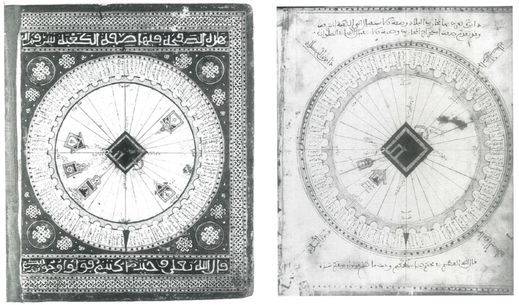
Then in 1989 the first Mecca-centred world-map (A) became available for study, and in 1995, before I really understood the first one, the second one (B) showed up …
| Source note: This was published in: David A. King. 1999, World Maps for Finding the Direction and Distance to Mecca: Innovation and Tradition in Islamic Science. London: Al-Furqān Islamic Heritage Foundation, pp. xvi-xvii. |
