Ekmeleddin İhsanoğlu
| Article contents: The Hellenistic-Islamic legacy ʿAjāʾib al-Mukhlūqāt (The Marvels of Creation) Early modern literature Modern literature Ambassadors’ reports (sefāretnāmes) and travelogues (seyahatnāmes) |
The development of Ottoman geographical literature reflects that of Ottoman science in general and, therefore, has many features in common with other scientific disciplines. It grew out of the pre-Ottoman scientific and cultural legacy, flowering into a new literary genre with contributions from scholarly circles in the new centres that were established within the expanding boundaries of the Ottoman realm, a realm that was to become a vast empire. Unlike other contemporary branches of science, however, an examination of Ottoman geographical writings reveals that there were early, intensive contacts on both practical and theoretical levels between Ottoman geography and the modern science of geography that was developing in Europe.
As I have sought to demonstrate in previous studies, the classical and modern traditions existed side by side in the Ottoman disciplines of astronomy mathematics and medicine, all of which followed a similar method of development. In the field of geography, however, the modern tradition became more prominent since the early period of sixteenth century, while the classical tradition became marginalised. This development was probably a result of the early demand for up‐to‐date geographical information and cartography and the fact that geography, unlike other branches of science, was not taught in the medreses and therefore had a different institutional background from them. Although scholars, educated in the medreses, produced works within the tradition of classical geography, and all kinds of intellectual and scholarly activity took place in the medrese circles, geography was not included in the medrese curriculum. This may explain the absence of a mechanism through which classical literature could be reproduced and continued.
With the expansion of their empire in the fifteenth and the sixteenth centuries, the Ottomans established a formidable naval force in the Mediterranean and beyond. Their fleets were to be found in the Black Sea, the Red Sea, the Persian Gulf and the Indian Ocean. Fighting against European navies in the early period of the empire, they were able to acquire essential, new information and techniques about navigation from their European rivals.
It is difficult to make a clear distinction between the classical and modern traditions in early examples of Ottoman geographical literature. Just, as in other manifestations of Ottoman culture, East and West, and old and new have always co‐existed and been intricately connected. Their separation has been fitful and lengthy. In the case of geography, however, this separation was relatively rapid: from the seventeenth century onwards, modern European geographical literature became more significant.
In the classical period there were two principal types of geographical literature. The first was part of the Muslim geographical tradition, having developed in the cultural milieu of the medrese. The second was literature produced by sailors and scholars who were not directly associated with the medrese, and which was largely based on European geography and cartography. In general, the literature, developed in medrese circles can be subdivided into two main categories: works on Islamic scientific geography and works of what could be called as popular geography.
The Hellenistic-Islamic legacy
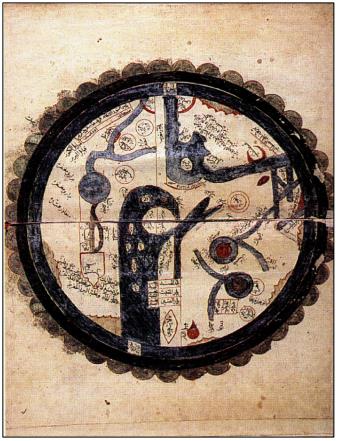
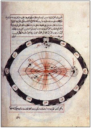
The Ottomans inherited the Islamic scholarly geographical tradition, which had, in turn, been influenced by the Hellenistic scientific legacy. Sultan Mehmed II was interested in geography and ordered the Byzantine scholar Amirutzes of Trebizond (d. 880/1475) and his son Mehmed to translate Ptolemy’s geographical works into Arabic. There are two copies of this translation in Ayasofya Library, nos. 2596 and 21601 The first copy cites Sultan Mehmed II’s name in the introduction but has no maps, while the second copy contains maps but not the Sultan’s name2. Ptolemy’s geographical work had previously been translated into Arabic on a few occasions during the early ʿAbbāsid period but copies of these translations have been lost; only the copies of the translation ordered by Mehmed II are extant today.
In addition to translations of Ptolemy, the classical Ottoman tradition includes works written by scholars in the tradition of classical Muslim geographers, for example, Awḍaḥ al-Masālik fī Maʿrifat al-Buldān wa al-Mamālik (A and T) by Sipāhī-zāde (d. 997/1589)3, and Manāẓr al-ʿAwālim (T) by Āşik Muhammed ibn Ömer (alive in 1022/1613)4. Such authors supplemented their own knowledge with material they gleaned from the works of classical Muslim geographers. It is important to acknowledge, that Ottoman scholars benefited from classical Arabic sources; there was, however, no pressing need to translate these books into Turkish since all Turkish scholars understood Arabic perfectly. There are, therefore, no complete translations of Arabic works written in the classical tradition, though there are some indications that Iṣṭakhrī’s (tenth century) book entitled Ṣūrat al-Arḍ or Kitāb al-Masālik wa al-Mamaālik was translated.

In addition, scholars who had been educated in medreses, wrote books about the merits and geography of places such as Makkah, Madinah, Damascus, Jerusalem, the Nile and Egypt, cities, rivers and countries within the territorial boundaries of the Ottoman Empire. The information on geography included in such works, greatly enhanced their significance.
Menzilnāmes (register books of travel stations) form another important genre of Ottoman geographical literature. They fall into two main groups: manāzil al‐ ḥajj (pilgrimage rest-houses) and military texts. There is a great number of the former in Ottoman geographical literature, written in both verse and prose. They describe the roads that stretch from Istanbul, Cairo and Damascus to Makkah, calculating the distances involved and the time needed to travel along them and detailing the characteristics of the settlements along the way. Among the most important is Manāzil al-Ḥaramayn (T) by Shams al-Dīn Muḥammad (tenth/sixteenth century)5, the oldest surviving work of its type. The next-oldest work is Manāzil al-Ḥajj (T) by Qayt al-Dāwudī (alive in 941/1534)6. Its importance stems from the fact that, unlike many other works, it gives the distances between stations on the basis of fersahs (one fersah being equal to three miles) rather than hours. Bahjat al-Manāzil (T) by Muhammed Adīb ibn Muhammad Derviş (alive in 1193/1779) should also be mentioned7. This work, which was published in Istanbul in 1232/1817, has a distinctive literary style. It was translated into French by M.Bianchi under the title of Itinēraire de Constantinople à la Mecque, traduction de l’ouvrage Turc: Kitāb Manāsik al-Ḥajj and was published in Paris in 1826. An important example of menzilnāmes written in verse, is the work entitled Waṣf al-Manāzil min Miṣr ilā Makkah wa min al-Shāam ilā Makkah wa min Dimashq ilā al-Quds (T) by Fethi Efendi (twelfth/eighteenth century)8. It is noteworthy to mention, that all these works were written in the tradition of classical geography and, most important of all, they contained information describing particular areas.
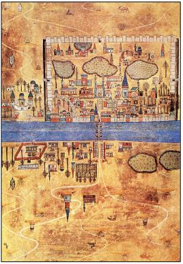
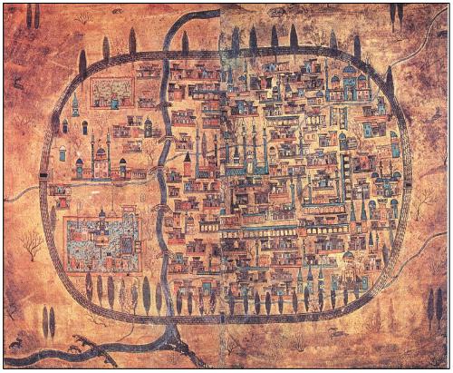
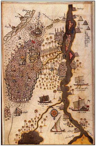
Works in the second category of menzilnāmes were written for military purposes. Most valuable among them is Beyān-i Menāzil-i Sefer-i Irakeyn (T) by Matrakçi Nasuh (d. 971/1564)9. It contains copious explanations, and also detailed pictures, of numerous cities and castles. A facsimile version of this work, which is of a high artistic standard, was published in 1976, in Ankara, by Hüseyin Yurdaydin, under the auspices of the Turkish Historical Society.
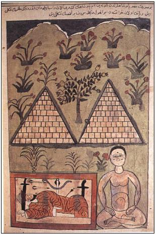
ʿAjāʾib al-Mukhlūqāt (The Marvels of Creation)
Another significant category of Ottoman geographical literature consists of translations and compilations based on the Arabic ʿAjāʾib al-Mukhlūqāt, and similar works in Turkish. Most of the authors of such books were educated in the medreses or had connections with them. The earliest examples of this genre are free translations from ʿAjāʾib al-Mukhlūqāt, written in an erudite, literary style. Amusing in tone, the works were a fabulous mixture of subjects such as cosmography, geography, botany and zoology. Essentially free translations of ʿAjāʾib al-Mukhlūqāt by Zakarīyah al-Qazwīnī (d. 681/1283)10 and Kharīdat al-ʿAjāʾib by Ibn al-Wardī in Turkish language, were supplemented with passages from other geographical works and information provided by the translators. There are 12 such Turkish translations in overall. The earliest among them are books entitled Terceme-i ʿAjāʾib al-Mukhlūqāt by ʿAlī ibn ʿAbdurraḥmān (alive in 800/1398)11 and Ahmed Bīcan (alive in 857/1453)12. They were the precursors of similar books appearing in the following centuries, the last of which appeared in the mid-twelfth/eighteenth century, and include Tekmile-I Terceme-I ʿAjāʾib al-Mukhlūqāt (T) by Rodosi – zāde (d. 1113/1701)13and Mirʾāt-i ʿAjāʾib al-Mukhlūqāt by Husayn ibn Mehmed (alive in 1115/1703)14. The most famous of these 12 Turkish ʿAjāʾin al-Makhlūqāt translations were those by Ahmed Bīcan Sürūrī (d. 969/1562)15 and Maḥmud ibn Aḥmad al-Khaṭīb al-Rūmī (alive in 970/1563)16. The other books in this tradition most of which are simply translations - are Dürr-i Meknūn by Ahmed Bīcan, Taḍkirat al-ʿAjāʾib wa Tarjamat al-Gharāʾib (T) by Ayyūb ibn Khalīl (alive in 977/1569)17, the translation of Ibn Zunbul’s Qānūn al-Dunyā (A) by ʿAbd alurrḥmān ʿAbdī Efendī (alive in 983/1575) entitled ʿAcāʾib-i Uzmā (T)18, ʿAjāʾib al-Makhlūqāt or Mirʾāt al-Kāʾināt by Ḥusām al-Dīn al-Burusavī (d. 1042/1632)19 and Terceme-i Mushʿil al-Azhār by Ridvan Paşa-zāde (twelfth/eighteenth century)20.
Early modern literature
Navigators and scholars who were not directly connected with the academic world of the medrese produced geographical works which were influenced by the pre‐modern school of geography that had developed in Europe and placed a strong emphasis on cartography. Among the earliest were the Tunisian Ibrāhīm al-Kātibī (alive in 816/1413)21 and the Andalusian Ibrāhīm al-Mursī (living in 865/1461)22, both of whom drew portolanos of the Mediterranean and Western Europe. It is likely that the Ottomans used the maps they produced but, unfortunately, we do not have, at present, sufficient information to elaborate on the nature of the relationship between Ottoman officials and these two cartographers from North Africa and Spain respectively.
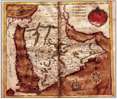
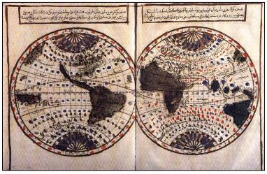
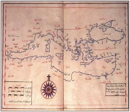
The navigator and mariner Pīrī Reis (d. Cairo 960/1554) pioneedred the European style of geography among the Ottomans23. His book, Kitāb-i Bahriye (T), in which he vigorously advocated the use of compass and maps, and his two World Maps were successful works in their time, they still attract the admiration of modern scholars. Containing much accurate information, particularly considering the limitations of the period in which they were produced, both the world maps and the maps in the Kitāb-i Bahriye are largely correct. Several copies of Kitāb-i Bahriye and parts of the world maps have survived to the present day. Kitāb-i Bahriye uses an elaborate Turkish language to describe in detail the Mediterranean and nearby waters, the Red Sea, Persian Gulf and the Indian Ocean: the islands, sea routes and shores, as well as the cities and castles around them. The book was intended as a guide to Ottoman navigators and in writing it Pīrī Reis drew upon the geographical works of Venetian, Genoese, Spanish, Portuguese and Ottoman navigators. Three editions of Kitāb-i Bahriye have appeared in Turkey and it has been the subject of several articles published by both Turkish and Western scholars.
Among other successful contemporary examples of this school of geography are works by Hacı Aḥmed al-Tunisī (alive in 967/1559)24 and Seydī Ali Reis (d. 970/1563)25 and also the Atlas by Ali Macar Reis (alive in 975/1567)26. According to historical accounts, there was a great interest in cartography in Istanbul at the time: the city became a centre for the development of modern cartography and there is even mention of a branch of artisans devoted to the work. In the seventeenth century, there were fifteen artisans working in eight shops in Istanbul, producing maps for sailors and all those interested in cartography. Familiar with Latin they could draw on the information contained in works such as Atlas Minor27 and Mappemonde to produce their own maps28.
We can cite books from the classical period of Ottoman history which combine knowledge taken from both the Islamic and European traditions of geography. One such example, is the Turkish work entitled Hadīs-i Nev or Tārih-i Hind-i Garbī (A History of the West Indies and the New World), attributed to Muḥammad al-Suʿūdī (d. 999/1591)29 which contains information about sixteenth-century geographical discoveries and the New World. Based on Spanish and Italian geographical sources, it is important, in the sense, that it reveals how closely the ottomans were following the geographical discoveries in the New World. It is composed of three sections, the first and second of which are concerned with the Old World and the Indian Ocean. However, the real weight of the work ‐ some two‐thirds ‐ is in the third section, where the voyages of Columbus, Balboa, Magellan, Cortes and Pizarro are related, covering the 60‐year period after Columbus’s discovery of America in 1492. The first and second sections were based on Islamic geographies and maps: the author makes frequent mention of these geographies and most often quotes al-Masʿūdī, thou such figures, as Ibn al-Waedī, al-Ṭūsī, al-Qazwīnī, al-Suyūṭī and Imām Rāzī, are also mentioned. In the third section on the New World, however, the author does not provide the titles or authors of the European geographies he has consulted. The inclusion in this work of discoveries made as late as 1552, brings home to us the extent to which the Ottomans were able to follow developments in the West.
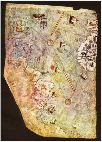
The fact that Ottoman geographers were able to obtain information about both the West and the East at a time when there were no accurate maps of the East available in Europe, is an indication that Ottoman cartography was more advanced than previously thought. The maps which Ottoman geographers produced can be divided into three categories: maps which integrate existing and newly acquired information, maps which are copies of European maps (the originals of which no longer exist) and original maps which were produced by Ottoman geographers. For example, Pīrī Reis’s maps of the Mediterranean and those maps prepared by Ali Macar Reis for his atlas which were based on his own observations are all original works.
Three copies of the Imperial Atlas (Atlas‐i hümāyūn), which seem to have been produced between the years 957/1550‐ 975/1567, have been located. These atlases were usually prepared for presentation to the sultan and share the same name because of their resemblance to each other. They contain portland‐type maps that were prepared by comparing the traditional and newly available information, making extensive use of Italian maps. They also, contain original maps of the Istanbul, Salonica and Gallipoli regions.
Modern literature
The understanding of Ottoman geography and cartography gained a new perspective with the works of Kātib Çelebi (d. 1067/1657), the famous seventeenth‐century polymath scholar, who mostly compiled during the Siege of Crete, 1645‐1669. Kātib Çelebi and his successors abandoned the classical approach to geography in which Islamic and Western attitudes coexisted. Instead, they favoured the method followed by those Western sources that were available to them30.
Having compared geographical works written in both East and West, Kātib Çelebi believed that the studies on geography conducted in the Muslim world, were inadequate for the needs of the day. He concluded that the Europeans had been able to establish their dominion over the world's oceans because they were in possession of superior geographical information. He also drew the attention of Ottoman intellectuals on this point. Hence, he examined Western studies on cartography and geography with the help of European converts. With the assistance of a French convert, Mehmed Ikhlasi, Kātib Çelebi translated Mercator’s (d. 1594) Latin work Atlas Minor into Turkish. He called this work Lawāmiʿ al-Nūr31.
Kātib Çelebi compiled his work Cihannümā with this new perspective on the basis of Western sources but without neglecting the Islamic ones and gave a list of them in the introduction of his book32. He also explained the method he followed in translating the Atlas Minor33.
It appears that in compiling his above-mentioned works, Kātib Çelebi mostly benefited from the previous works in the field. Nonetheless, the compilation of Cihannümā is a great development in the history of Islamic geographical literature, a point that he draws attention on it in his introduction34.
In the seventeenth century, Ottoman interest in European geographical sources was much greater than it had been in the early period (the fifteenth and sixteenth centuries). Two reasons may be cited for this. First, Muslims in general, and Ottomans in particular, were intellectually curious about what lay beyond the Muslim world and turned to European geographical works to supplement their knowledge. Secondly, the Ottomans acknowledged the important role that geography and cartography had played in European expansion as well as in enhancing and increasing European military and political power. The Ottomans were consequently keen to learn about contemporary geography, in response to an ‘invasive’ Europe. Spurred on, by these two considerations, particularly from the beginning of the seventeenth century onwards, the Ottomans made sure they had access to new knowledge on the Far East, Europe and America through geographical books which were translated from European languages such as Latin and French and which contained accurate and systematic information. As can be seen in Kātib Çelebi’s Cihannümā, for example, by obtaining new information, Ottoman geographers were able to develop a significant new category of geographical literature. They supplemented information on the Islamic world that did not exist in the West with knowledge that they transferred from the West. Although Kātib Çelebi, mostly drew on existing studies in his writings, his book Cihannümā must be regarded as a landmark in Muslim geographical literature.
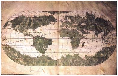
Cihannümā is considered to be the most important geographical book written in Turkish after the efforts of Pírí Reis. In later periods, Ottoman geographers began to draw upon European sources at a gradually increasing rate. Kātib Çelebi made use of another work known in brief as Atlas Major which was written by Willem J. Blaeu (d. 1638) and his sons Joan and Cornelis35. It appeared in 9‐12 volumes (Amsterdam, 1662‐1665). Çelebi drew the attention of statesmen on this work.
Atlas Major, one of the most remarkable works of its time, was translated into Turkish by Abū bakr ibn Bahrām al-Dimashqī (d. 1102/1691)36 after he had been encouraged to do so by Mehmed IV (d. 1693), shortly after the book was first published. This translation, entitled Nuṣrat al-Islām wa al-Surūr fī Taḥrīr-i Atlas Major (T) was completed in 1685.37 This work, which gives extensive information about the history and geography of Europe and America, also contains several maps. It is divided into sections about different countries, each section containing detailed information about physical and human geography: agriculture, forests, people, customs, historical monuments, cities, political administration, and educational and religious institutions. Al-Dimashqī produced a free translation of this work in nine volumes; volume I is devoted to general geography and cosmography, volumes II to V to Europe, volume VI to Africa, volume VII to Italy, volume VIII to China and volume IX to America and the Indies.
Al-Dimashqī wrote two works more on the basis of this translation. One is an abridged version of the translation of Atlas Major entitled Mukhtaṣar Nuṣrat al-Islām wa al-Surūr38 (T) which includes a supplement on Ottoman geography. The second, entitled Risālah fī al-Joghrāfīyā39, is a short treatise in Arabic, dealing with subjects such as physical and human geography, climates, the shape of the earth, the stars, zodiacs and astrology. It also includes technical information on the compass.
After him, other geographers such as Petros Baronian (alive in 1151/1738)40, Ibrāhīm Müteferrika (d.1160/1747)41, Bartınlı Ibrahim Hamdi (alive in 1163/1750)42, and ʿOsman ibn ʿAbd al-Mannān (d. around 1200/1786)43, most of whom were converts, produced works based on translations from Latin and other European languages. Petros Baronian translated Jacques Robbs’s La Méthode pour apprendre facilement la géographie into Turkish, under the title of Cem-nümā fī Fan al-Coǧrafya. The interest that Kātib Çelebiʾs Cihannümā created in scholarly circles when it was printed by Müteferrika, inspired Baronian to translate Robbs’s work. This work contains information about European mathematics, physical geography and maritime astronomy that had not previously been available in Turkish44 as well as a discussion of map‐making and the mathematics of projections. Baronian also included a map of the Mediterranean in the book, giving scales using Islamic, French and Italian fersahs.
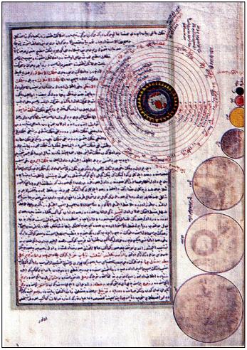
Ibrāhīm Müteferrika, well‐known as the founder of the first Muslim printing house in the Ottoman world, was at the same time a diplomat and a polymath scholar. Müteferrika also considered himself as a geographer and, in 1730, printed an edition of Tārih-i Hind-i Garbī, attributed to Muḥammad al-Suʿūdī. He followed this with an edition of Cihannümā in 1732, adding maps and various supplements to the original text. Müteferrika included new information on Anatolia and Arabia taken from Abū Bakr ibn Bahrām al-Dimashqī’s translation of Atlas Major and in a further supplement entitled ‘Teḍyīl al-Tābiʿ, gave details on new astronomy’s theories. He also gave detailed expositions on subjects such as Ptolemy’s, Copernicus’s and Tycho Brahe’s models of the universe, Descartes’ whirlpool theory, and the contributions of Aristoteles and Galileo to astronomy.
Bartınlı Ibrāhīm Ḥamdi wrote a work entitled Atlas‐I Cihān. In writing this, he drew upon books entitled Atlas Coelestis, Coǧrafya‐yı Cedīd and Atlas‐ı Cedīd‐i Felemenk. He also included translations of some sections of Engineer Karyo’s book on military history, Gaspar Scott’s book on mathematics and military architecture and Raymond Graf von Montecucculi’s (d. 1680) work entitled Commenterii Bellici45.
Osman ibn ʿAbd al-Mannān (d. around 1200/1786) translated Geographia generalis in qua affectionnes generalles telluris explicantur by Bernhard Varenius (1600‐1676) from German into Turkish, in 1751. Varenius’s work, which was published by Newton himself, is one of the most important to have been written in the fields of mathematics, physics and physical geography. ʿAbd al-Mannān made a free translation of this work under the title Tercemetü Kitāb-i Coǧrafya (T), stressing the topics of astronomy and physical geography but excluding other sections related to mathematics and physics. He also expanded upon Varenius’ introduction and conclusion, and gave it a new structure. In the introduction he discussed the earth’s position in space. ʿAbd al-Mannān added new information on Ottoman geography and listed the historical information chronologically according to hijrī dates. As a result of this book and those mentioned above, modern geography and astronomy, including Copernicus’s theory, were firmly established in Ottoman scholarly circles46.
Ambassadors’ reports (sefāretnāmes) and travelogues (seyahatnāmes)
A further A further subdivision of Ottoman geographical literature is made up of several books of descriptive geography, both original works and translations into Turkish, works written in the form of travellers’ memoires and ambassadors’ reports (to the sultan). Such books date from both the classical period and the period of modernisation. The earliest of these is Hıtaynāme by ʿAli Akbar Hıtāī (alive in 922/1516)47. The book, which was originally written in Persian and subsequently translated into Turkish by its author, describes Hıtāī’s impressions of China. The work entitled ʿAcāʾibnāme-i Hindistān by ʾAhmad ibn Ibrāhīm al-Toqādī (tenth/sixteenth century) is another fascinating example of this genre48.
From the twelfth/eighteenth century onwards, there was a great increase in the number of sefāretnāmes or ambassadors’ reports, most of which described European countries. In the History of Geographical Literature during the Ottoman Period (OCLT) we have included the ambassadors’ reports that pertain to geography as well as those that contain information about the political, physical and human geography of the countries that the ambassadors visited. Works of this kind did not restrict themselves to a mere account of political matters.
Notable among such works are those sefāretnāmes, which were written by statesmen who were also men of letters, such as Yirmisekiz Mehmed Çelebi49, Aḥmad Resmī Efendi50 and Aḥmad Vāsıf Efendi51. They are of significant importance because they contain a great deal of information about the human geography, culture and civilisation of the countries that the ambassadors visited. Thanks to such works, Ottoman administrators and intellectuals could better understand European countries. It was only natural that the opinions of these ambassadors on the things they came across, what they focused their attention on, and what they described, had an important impact on the development of Ottoman intellectuals’ perception of the world at large.
In addition to the sefāretnāmes that describe the impressions of delegations sent to Europe, there are also ambassadors’ reports produced under the influence of the classical period. Foremost among them is Bozoklu Osman Şākir’s (d. 1232/1817) Musavver Iran sefāretnāmes52. This book does not contain the same kind of information as the works of Ahmed Resmī and Yirmisekiz Çelebi but rather, in a similar way to Matrakçı Nasuh’s work, it includes meticulously drawn miniatures of several areas of Anatolia. A comparative study of these works indicates the use of both classical and Western traditions by Ottomans.
In addition to the above works, the Seyahatnāme of Evliyā Çelebi (d. 1093/1682) is worthy of mention. It is the most extensive travel book about the Ottoman world and, at the same time, one of the most comprehensive examples of the genre in world literature; all in all, it is an invaluable literary and historical work53. In this famous opus of ten volumes Evliyā Çelebi gives a lively account of the history, culture and folklore of the areas which he visited. He also gives a lot of information about the geography of the provinces and cities, located in the European, Asian and African parts of the empire, such as Greece, Transylvania and other Balkan provinces, Syria, Iraq and Egypt. He also gave detailed reports on his observations of neighbouring lands such as Hungary, Austria, Azerbaijan, Georgia, Astrakhan and other Caucasian areas where he travelled, when taking part in military campaigns. We will look below at similar important travel books written in the modernisation period by Ottoman intellectuals.
The drive towards military modernisation, which had already begun by the beginning of the eighteenth century, gained further momentum after the Russian defeat of the Ottoman naval forces at Çeşme in 1770. The most conspicuous manifestation of this movement was the new Military Engineering School, established in 1775 in the maritime arsenal along the lines of European military institutions. The school, commonly known as the Hendesehāne, was renamed the Mühendishāne in 1781. We know that the first students who studied in the Hendesehāne undertook land surveys, but, unfortunately, the original curriculum of this institution has not survived to the present day and we cannot be sure that it contained courses on geography. Geography and cartography were later included in its curriculum and, as a result, stimulated a lively growth on Ottoman geographical literature. In 1797, departments of ship construction and navigation were established at Tersāne Mühendishānesi, where cartography was taught. Tersāne Mühendishānesi took the name of Mühendishāne‐i Bahrī‐i Hümāyūn (School of Naval Engineering) in 1806 when the Law of Engineering Schools was put into effect. According to this law, courses on geography were to be included in the curricula of the second and third classes of the Mühendishāne‐i Cedīde (New Engineering School), which had been set up in 1793 by Selim III under the name of Mühendishāne‐i Berrī‐i Hümāyūn (School of Military Engineering)54.
Hüseyin Rıfkı Tamāní (d. 1816), the first chief instructor of the Mühendishāne‐i Berrī‐i Hümāyūn, wrote a textbook in Turkish entitled al‐Madkhal fí al‐Coǧrafya (Introduction to Geography) for use in the school. It was published by his former student Ishak Efendi in 183055. The geography courses taught in the Mühendishāne were also included in the curriculum of the Military Academy that was established in 1834. Geography and cosmography were taught in the second and the third preparatory classes of this school respectively56. During the Tanzimat period geography courses were included in the curricula of the middle‐ level secular schools known as the rüşdiyes and the idādīs. Thereafter, several geography textbooks were also written. Selim Sābit Efendi (d. 1910)57, for example, published a guidebook for teachers, entitled Rehnümā‐yı Muallimīn (T), in 1874. In the introduction he stated that ‘in geography classes the students would learn about the five continents and they would be taught how to draw maps58.’
From the beginning of the nineteenth century onwards the Ottomans abandoned traditional geography completely and, instead, closely followed European developments in geography. The production of geographical manuscripts, therefore, ceased. Astronomical, mathematical and even medical manuscripts based on traditional science were still produced in the nineteenth century but this actually depended upon whether or not these sciences were still taught in classical institutions. Since geography was not included in the curricula of the medreses, the production of geographical manuscripts ended at an early date.
As medreses lost their position at the centre of the Ottoman educational system and institutes and schools providing military or civil higher vocational education flourished, some graduates of the engineering schools and the Military Academy, who were educated in Europe, produced original cartography and geographical works. Some medrese graduates were even involved in modern geography. During this period many books were prepared along with the school curricula. As a result, during the second half of the nineteenth century, the number and range of geography books increased drastically, mirroring developments that had occurred in other fields. The number of original works increased significantly, especially in topics related to the Ottoman Empire as a whole, or to its provinces. Ottoman geographers also became interested in Africa and Asia, especially Japan. Developments in Japan drew the attention of many Ottoman intellectuals, who then wrote about the country.
During his reign, ʿAbd al-Ḥamīd II, was actively involved in domestic policies and sent many missions to the outlying European, Asian and African provinces of the Ottoman Empire. Similarly active in foreign affairs, ʿAbd al-Ḥamīd also sent experts further afield. All such missions were asked to prepare reports, a significant number of which were kept in manuscript form and were later published as books.
Apart from these officially inspired journeys, Ottoman intellectuals also travelled abroad on their own initiative and wrote accounts of their travels. Others translated books, about travel in Africa, Australia and the Poles, into Turkish. In this study, I have focused on books related to geography which provide information on the political, physical or, human (beşerī) geography of the countries or regions in which their authors travelled. Translations of travellers’ accounts, in the form of novels or works that merely relate the emotional responses of their authors to the countries they visited, have not been included.
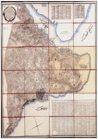
In the nineteenth and twentieth centuries many original Turkish works which were written in the modern tradition, as well as Western geography translations were published. The same can be observed in cartography: new maps were drawn and European maps were translated. Ottoman provinces were surveyed and accurate maps prepared. Ali Şeref Paşa (d.1907)59 and Mehmed Şevki Paşa (d. 1927)60 were especially active in developing the study of surveying and cartography.
In addition to official military maps, among the most significant cartographic works of this period are: maps of the Basra‐Baghdad and Baghdad‐Mosul regions by Muʿallim Ali Bey (d. 1266/1849)61; maps of Istanbul and the Arabian Peninsula by Hüsnü Bey (alive in 1278/1861)62; the map of Syria‐Aleppo‐Adana‐Zor by Ismāil Zühdi Bey (alive around 1303/1886)63; the map of Arabia‐Acemistan‐Turkistan by Hacı Mahmud Bey (alive around 1308/1890)64; the work titled Memālik‐i Mahrūse‐i Osmāniye Harita‐i Umūmiyesinin Usūl-i Tastīhi ve Tersimātı Hakkında Tedkikāt‐ı Fenniye (T) by Menemenlizāde Ömer Kāmil (alive around 1310/1892)65, the book Atlaslı Coǧrafya‐yı Osmānī by Mehmed Nasrullah (alive in 1909)66; the Central Anatolian map by Ismail Remzi (alive in 1907)67, and the map of Eastern Anatolia‐Caucasia‐Syria Egypt‐the Black Sea‐Iran by Hattat Azmi of Diyarbekir (alive in 1912)68.
There is also a tradition of Ottoman general or national (umumī) geography, where Memālik-i Mahrūse-i Şāhāne Coǧrafysı (T), the first comprehensive work on Ottoman general geography, by Mustafa Rāsim (alive in 1305/1888)69, Coǧrafya‐yı Mufassal‐ı Memālik‐i Devlet‐i Osmāniye (T) by Ali Sāib (alive in 1308/1890)70, and Memālik‐i Mahrúse‐i Şāhāne Coǧrafyası (T) and Mufassal Memālik‐i Osmāniye Coǧrafyası (T) by Ali Tevfik (alive in 1911) can be cited71. It is, however, important to note that some works of Ottoman general geography were scarcely more than compilations of information found in the official salnāmes (yearbooks) published by the state, although there were other works by Ottoman scholars on general Ottoman geography, or on a specific area of Ottoman geography, based on personal investigation (taḥlíl).
In the same period, many works were produced focusing on the economic, military and strategic geography of the Ottoman Empire as well as tahdīd‐i arāzi (land surveying) and topography. Mehmed Hüsrev (alive around 1302/1885)72 wrote Memālik‐i Osmāniyeʾnin Coǧrafya‐yı Ticārīsi (T), the first Turkish work on commercial geography. Coǧrafya‐yı Zirāī ve Sınāī ve Ticārī (T) by Hüseyin Rahmi (alive in 1307/1890)73 and Memālik‐i Osmāniyeʾnin Ziraat Coǧrafyası (T) by Hüseyin Paşa (alive around 1902)74 are noteworthy books on agricultural, industrial and commercial geography. Hüseyin Paşa informed us that while writing his book, he relied on many sources, both foreign and Turkish. Memālik‐i Osmāniyeʾye Mahsus Coǧrafya‐yı Askerī (T) by Ahmed Cemal (alive in 1310/1892)75, was the first book to appear on military geography. Hüseyin Hüsni (alive around 1310/1892)76 wrote on similar subjects, producing six works on military geography and topography. Coǧrafya-yı Askerī ve Sevkülceyşī (T) by Mehmed Tevfik, (alive in 1909)77, is another important work. While preparing this, he used many sources not previously used by the Ottomans. In addition, memorable are several works by Seyyid Ismail Hakkı (presumably alive in 1912)78, Mustafa Şevki Paşa (d. 1912)79 and Ahmed Şükrü Paşa (d. 1915)80 on strategy, Taksim-i arāzi (land division) and topography.
From about the end of the eighteenth century onwards, several dictionaries appeared in Europe about general and regional geography and history under the title of Dictionnaire universelle d’histoire et de gēographie. Works of this kind can be found in classical Islamic geographical literature, but geographical dictionaries, in the modern sense of the word, were only written by the Ottomans from the second half of the nineteenth century and onwards. The earliest example of such works is Lügat‐i Tarihiye ve Coǧrafiye (T), which was compiled by Yaǧlıkçı zāde Ahmed Rifat (d. 1312/1894)81. This work was followed by Kāmus al‐Aʿlām (T), written by Şemseddin Sāmi (d. 1904)82, and Memālik‐i Osmāniyeʾnin Tārih ve Coǧrafya Lügatı (T), written by Ali Cevad (d. 1914)83. Şemseddin Sāmi’s book is a wide ranging and comprehensive work. Until the publication of Islam Ansiklopedisi, which is an expanded Turkish translation of The Encyclopaedia of Islam published in Leiden, it was the most widely known book in its field and is still used today by intellectuals in Turkey and scholars of Ottoman Studies
Several school textbooks were also published in this period, including works by Süleyman Şevket Paşa (alive in 1310/1892)84 and Abdurrahman Şeref (d. 1925)85 which were used for many years. Faik Sabri Duran (d. 1943)86 and Osman Safvet Geylangil (d. 1945)87 also published several textbooks which resemble each other in that they were based on sound pedagogical principles. Their books continued to be taught in schools during the Republican period from 1923 onwards.
Travel books (seyahatnāmes) of the modern period have a particular place in Ottoman geographical literature. These include reports about the Ottoman provinces written during the reign of ʿAbd al-Ḥamīd II and the period of the Second Constitution, as well as noteworthy records of journeys undertaken by individual Ottoman intellectuals. Most of these works are still in manuscript form. Throughout Ottoman history, the study of geography has continuously expanded, along with other scientific disciplines. The flourishing in geographical literature does, however, differ from that of astronomy and mathematics88.
Geographical texts increased greatly in number in three major leaps ‐ in the sixteenth, nineteenth and twentieth centuries respectively. A mere four works on geography were produced in the fifteenth century, but the output increased dramatically to 48, in the sixteenth century. This rise can be explained by the growth in Ottoman naval power and their campaigns fought in the Mediterranean, the Black Sea, the Red Sea, the Indian Ocean and the Persian Gulf. To a great extent, the second leap, which took place in the nineteenth century, resulted from the increasing demand for books on modern geography, to be used in the new schools and modern educational institutions, which had recently been established throughout the empire. During the first quarter of the twentieth century, the number of works on geography increased approximately four times over the number produced in the preceding century.
There have, over time, also been great changes in the proportions of geographical works produced in manuscript and printed forms. For example, 47 geographical books were produced during the period from the printing of Tārih‐i Hind‐I Garbī and Cihannümā, among the first books on geography to be printed at Müteferrika Printing House in 1729, to the nineteenth century. Of these 47, only 7 were printed while the remaining 40 were in the form of manuscripts. During the nineteenth century, however, only 68 of the 244 works were in manuscript form, while the number of printed works increased to 176. In the first quarter of the twentieth century, the ratio of printed books to manuscript works increased greatly. Only 4 of the 335 works dating from this period were manuscripts, while the rest were printed works.
As can be understood from this explanation of the different strands of Ottoman geographical literature, which has also sought to highlight major developments and introduce the reader to the seminal, influential texts, this literature constitutes a rich and vast field of research. A detailed and in‐depth examination of the several manuscript works contained in OCLT, reveals that before the transition of Ottoman science from the Islamic to the European tradition, geographical works were in the form of manuscripts. In the later period, however, printed books formed the majority.
*This article can be considered a summary of the survey by E. Ihsanoğlu, R. Ṣeşen at al., Osmanli Coğrafya Literatürü Tarihi (History of Geographical Literature during the Ottoman Period), (ed.) E. Ihsanoğlu, (2 vols, Istanbul, 2000), [OCLT]. To avoid long lists of footnotes in this study only the references in OCLT that were deemed essential have been included. For an overview of Ottoman science see E. Ihsanoğlu (ed.), History of the Ottoman State, Society and Civilization (Istanbul, IRCICA, 2002) vol. II; for scientific institutions see pp. 357-515 and for scientific literature see pp. 517-603. Books in Arabic and Turkish are indicated as A and T.
| Source note: This was published in: The Earth and its Sciences in Islamic Manuscripts: proceedings of the fifth conference of Al-Furqān Islamic Heritage Foundation – English version, 2011, Al-Furqan Islamic Heritage Foundation, London, UK., p 101-140. |