Roshdi Rashed
Bibliographers have often organised their books and catalogues along lines inspired by traditional teachings: so after the Qurʾānic sciences come the Prophetic Ḥadīth, followed by the sciences of language, then mathematics, astronomy and so on. This order is not, however, the one followed by the first Arab bibliographers, notably Ibn al-Nadīm, al-Qifṭī and Ibn Abī Uṣaybiʿah.
It is in order, however, that Brockelmann set up the different chapters in his monumental work, Geschichte der Arabischen Literatur, and it is with this order that his successors proceeded. Later encyclopaedists, such as Ibn Khaldūn and Ibn al-Akfānī, observed a similar order and used the same general methods. These encyclopaedists tended to detail and separate disciplines, while modern bibliographers, on the other hand, unify them. Because of their closeness to later encyclopaedists, modern bibliographers have the opportunity to make use of the work already accomplished but, by forcing the unification of various categories, they have ended up obscuring entire disciplines. Thus, they have adhered to this particular order of ‘exposition’ at the expense of the initial ordering of many sciences.
The problem presented, is largely the result of two factors. As they were not themselves ‘historians of science’, bibliographers had a tendency to blur the distinctions between disciplines and the writings within them. Historians of sciences, conversely, who were very rarely bibliographers, were not particularly interested in the history of the manuscript tradition.
If we turn our attention to the tenth century, we find al-Fārābī’s The Classification of Sciences. This is a work from which many of his successors borrowed – including Ibn Sīnā himself – and in which al-Fārābī presented a complex group of disciplines. This complex group was given the title ‘ʿilm al-ḥiyal’ (the science of ingenious procedures). It consists of a collection of disciplines that would later become known as ‘mixed sciences’ in the sense that mathematics, being an abstract discipline, can be combined with material elements. The concept underlying this group of disciplines was that ‘knowledge’ (ʿilm) and ‘action’ (ʿamal) were not mutually exclusive, but rather complementary. This concept permits the elaboration of two main principles. First, the possibility of introducing the art's rules and instruments into the heart of science. Secondly, that science can be used for purposes for which science is not the limiting framework, and which can therefore reach objectives outside its own limits. Thus, if knowledge aims at action, action, in turn, is based on knowledge. With this concept, a new definition of science can be given, without complying with either the Aristotelian or the Euclidean outline. This new relationship between knowledge and action, and between science and art, exceeded the boundaries that Aristotelianism had drawn between them – at least in theory – and conferred legitimacy on the application of science.
It is within the group of ʿilm al-ḥiyal that we find, for example, the arts of al-misāḥah (surveying), architecture, burning mirrors and even algebra, applied to both geometry and arithmetic. But the ‘exposition’ order followed by bibliographers, has fragmented this complexity and scattered it over different chapters. Thus, we find that entries for al-misāḥah have been integrated into chapters on mathematics, resulting in the disappearance of al-misāḥah as a separate discipline. The same fate befell the other disciplines that constituted the ʿilm al-ḥiyal group: in this way, then, in just one blow a specific group of sciences was lost and a group, defined by those who had seen it, emerged and developed. Furthermore, it is in precisely this group of sciences that we find most of the mathematical disciplines that have as their aim the study of the earth.
To describe the earth, represent it and ponder over it, were the aims of most sciences grouped under the ʿilm al-ḥiyal umbrella, all of which had a real impact on the history of mathematics. Closely associated during the tenth century, these disciplines were weakened by Newton’s theories. Until then, our inhabited planet had been at the centre of a closed and hierarchically ordered universe. The unity formed by these disciplines, and others with which they were associated, was ensured by earth’s central position in a finite world.
In the world’s earliest civilisations, astronomy was conceived as an attempt to know and understand the dimensions and shape of our planet. Additionally, as its name indicates, geometry was originally a science for measuring the earth. We all know that from the earliest times the Egyptians, Babylonians and Greeks were all interested in astronomy, geometry and geography. Yet it was only with the formation of the Islamic world that the close links connecting mathematics to earth’s knowledge became the object of intense and fertile research. In the fourth century hijrī many mathematical disciplines designed that the contemplation of the earth had already emerged. Among these were ʿilm al-misāḥah (surveying), ʿilm tasṭīḥ al-kurah (projecting the sphere), ʿilm al-ālāt al-ẓillīyah (instruments of shadows), ʿilm al-asṭurlāb (the astrolabe), mathematical geography, navigation, and so on. In all these sciences, however, manuscript research is still very much in its infancy. Catalogues of these manuscripts are yet to be compiled, few of the texts have been edited and any historical account of these texts is still undeveloped.
In this chapter, I will briefly consider a few examples. I will follow a reasonable method which leads an earth’s inhabitant locating his position, and that of his immediate environment, to one that surrounds him. I will therefore start with the science of measurements, ʿilm al-misāḥah.
Ancient literature dedicted to the science of measurement is very rich. Many names, such as those of al- Ḥasan ibn al-Ṣabāh, Ibn Najīyah, Ibn Bārāzā and so on. Were evoked by Ibn al-Nadīm in his Fihrist. One can add al-Khwārizmī, al-Kindī, Abū Kāmil, al-Qabīsī and, later on, ʿAbd al-Qāhi al-Baghdadī, al-Asfazārī, al-Karajī and their successors. The fourteenth-century bibliographer Ibn al-Akfānī provided other names and titles in his Irshād al-Qāṣid. This list is evidence of writings devoted to the art of measurement by mathematicians of classical Islam, proving that they both wanted to develop the discipline in its own right and further that they knew how to do so. As I have already mentioned, modern bibliographers do not classify this discipline by its proper name, despite its clear identification in encyclopaedists’ writings, such as Ibn al-Akfānī and Tashkūprī-Zādah.
In addition, works on measurement have yet to be listed and their history to be written. This is not, however, the aim of my current work. I will focus instead on a major contributor to the history of this discipline: namely, Ibn al-Haytham (d. after 1040 CE). Ibn al-Haytham left us two pieces of writings on this subject. The first is a veritable manual, Fī Uṣūl al-Misāḥah (The Principles of Measuring) and the second is a treatise on stereometry, Fī Maʿrifat Irtifāʿ al-Ashkāl al-Qāʾimah wa Aʿmidat al-Jibāal wa Irtifāʿ al-Ghuyūm (On Understanding the Height of Upright Objects, the Altitude of the Mountains and Height of the Clouds). We should also name a third text which probably covers the same subject matter. This was referred to, by early bibliographers as Masʾalah fī al-Misāḥah (On a Question of Measurement). We have at our disposal four copies of the manual, the only complete, being in St Petersburg. With this work, Ibn al-Haytham sought to provide a textbook for surveyors on the art of measurement. Although this is somewhat basic, it is nevertheless meticulous. Not only does it provide surveying with a solid foundation, it also provides a reference work of practical formulae.
After an introduction in which he sets out the basic concepts of the art-measurement units, measurement and measurable quantities, Ibn al-Haytham devotes the first chapter to the measurement of both straight and circular lines, the only ones that measures needed. In the second chapter, he studies the measurement of surfaces: rectangles, triangles, convex polygons and circles.
The third chapter deals with the measurement of three-dimensional objects: polyhedral, cylinders, cones and spheres. In the fourth chapter, Ibn al-Haytham proposes an experimental determination of the height of any body standing above the ground; the determined height, should be the perpendicular from the highest point of the solid body to the base. The techniques suggested by Ibn al-Haytham are effective even when one or both points (top or base) of the perpendicular is out the surveyor’s reach, for example, the peak of the mountain located on the other side of a river.
The stereometric problem examined by Ibn al-Haytham in his second treatise had already been studied by al-Kindī and Sinān ibn al-Fatḥ in their writings on optic measurements (misāḥāt al-manāẓir). However, Ibn al-Haytham rounded off his book with what is called a ‘textbook for the surveyor’, where he rewrote all the measurement results and techniques, but without the demonstrations. In this respect, he probably sought to provide the surveyor with a notebook so that he could easily and quickly find the necessary formula. Without focusing on either the demonstrations of Ibn al-Haytham or on his technical details, we should take into account his profound and original approach, which related the measurement of curved lines to straight ones and the measurement of curved surfaces to flat ones, so that all was reduced, in the final analysis, to linear measurements. These measurements were recorded in an arbitrary chosen unit; they were also expressed in numbers, both rational and irrational. Ibn al-Haytham introduced, in effect, a numerical concept to the relations between magnitudes. As in the rest of his work, Ibn al-Haytham observed a regulated. (methodical) approach: the properties and demonstrations of stereometry are modelled, as much as possible, on the properties and demonstrations of plan geometry. In this treatise on measurement, as well as in his treatise on isoperimeters, Ibn al-Haytham broke polygons down into triangles and, in a similar way, polyhedrons into pyramids.
This pioneering study by Ibn al-Haytham was the outcome of a researcher’s tradition inaugurated a century and a half before and, therefore, represents a historical as well as an epistemological event. Are we not witnessing here the most esteemed theoretician of geometry of his time writing a book intended for surveyors? Admittedly, Ibn al-Haytham was not the first to take this path. We will see below that his predecessor, Ibn Sinān, had no hesitation in producing a textbook on sundials’ construction. To my knowledge, however, no great geometrician of the Hellenistic period undertook this type of writing. Theirs was a new thought, fully committed to a double approach, and aimed at two closely linked objectives pursued by mathematicians: to create a geometrical art – the measurement of the earth – and to provide rules to be applied by practitioners of this art. A new knowledge was born, and a new literature blossomed. We will never appreciate them, unless we make the effort to distinguish and understand the authentic tradition of their manuscripts.
The art of earths measuring allows man to describe and to know his location. If, however, he does not want to became the prisoner of his location and for some, personal or general, reason wishes to explore faraway places, he must be able to locate himself in space and in time. He must also acknowledge other disciplines in order to be able to represent – in geometric form – the locations and times of different places and also draw maps and charts of the skies and the seas. The geometry of Archimedes and Euclid was insufficient to establish this discipline. Although the need for such a discipline was felt early on. The Islamic world took the responsibility to fulfil it.
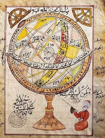
ʿIlm tasṭīḥ al-Kurah (the science of the projection of the sphere) was one mathematical science necessary if man were to meet his need in identifying specific locations. It was also essential for creating astrolabes as well as in cartography. This constitutes the foundation upon which the geometric representation of locations on the surface of the earth and the graphic representation of distances were built. Let us listen to an encyclopaedist:
It is a science by which we know how to map a sphere onto a plane, it concerns the lines and the circles drawn on the sphere, and how to map circles onto lines.1
Tashkūprī-Zdah reminded us of the main authors who worked on this subject and the books they wrote:
Among the ancient books in this science is that by Ptolemy on the projection of the sphere, and among the modern al-Kāmil by al-Farghānī, al-Istīʿāb by al-Bīrūnī and Ālāt al-Taqwīm by al-Marākūshī.
This sixteenth-century scholar’s opinion was not only his opinion; it was commonly held from at least the eleventh century, that is, just after this ‘science of projection’ became a specific branch of both basic and applied geometry. It was, for example, the opinion of al-Bīrūnī, Ibn al-Sārī and many others.
The question now raised is the following: when did this ‘science of projection’ become independent of astronomy and instead became a branch of geometry that can be applied to mapping? Before proceeding, let me remind the reader of two historical facts. The first is well known and concerns scientific research in Baghdad around the middle of the ninth century. According to al-Farghānī, a member of the scientific community and observer of his fellow scientists, the problems of projection were often discussed and were even the subject of controversy among mathematicians, notably Banū Mūsā, al-Kindī, al-Marwarūdhī (al-Maʾmūn's astronomer), al-Farghānī and others. The second fact is less well known: all such problems related to mapping and to astrolobes' construction were raised in the light of a recent translation of Apolonius's Conic Sections. For astronomers and geographers, the main problem was how to figure out a projection able to guarantee such mapping and, moreover, to rigorously prove it. Apollonius (second century BC) though not interested in the question of projections, he, prepared the way for a new geometrical research through his study on the intersection of a cone and a plane.
This encounter between the problems of mapping and the theory of the astrolabe on the one hand, and the geometry of conic sections on the other, took place in the ninth century and is documented in al-Farghānī's al-Kāmil. This crucial event left a visible impression on the form as well as the content of al-Kāmil. On the formal level, al-Farghānī devoted a special chapter to the geometry of projections entitled the ʿIntroduction of Geometrical Propositions by which it was proved the Figure of the Astrolabeʾ. In his introduction, al-Farghānī gives one of the first geometrical investigations of conical projections.
Without going into geometrical technicalities, let me remind you of al-Farghānī's main findings. He proved that the conical projection of a sphere through a pole P on the tangent plane at a point opposite to the pole P on a diameter, or a plane parallel to this one, is a stereographic projection. This conclusion was fundamental for mapping the sphere, which was the main problem for geographers and those interested in the theory of the astrolabe.
Al-Farghānī's important study was purely geometric although it had been undertaken to fulfil the needs of astronomy and geography. The seminal works of mathematicians and astronomers of the ninth century were followed by many others who became increasingly aware of the ‘science of projections’. In this respect, research undertaken by Banū Mūsā, al-Kindī, al-Marwarūdhī and al-Farghānī was followed by that of another generation of important mathematicians who pushed the investigation much further. Let me remind the reader of just a few of these names, not least Abū al-ʿALāʾ ibn Karnīb, Abū Yaḥyā al-Mawardī, Ibn Maʿdān and Ibn Sinān. It is to be regretted that not one of their contributions has been studied; even al-Farghānī's al-Kāmil has, as yet, remained unedited. In order to appreciate better the development of this new discipline, I will now jump to the third generation, the generation belonging to the last third of the tenth century. Let me here briefly summarise Abū Sahl Bijān al-Qūḥī's contribution, nearly one century after al-Farghānī's. Al-Qūḥī was one of the most important scientists of the tenth century and a member of ʿAmud al-Dawlah and his son Abū al-Fawāris Sharaf al-Dawlah's court.
In his book The Art of the Astrolabe by Demonstration, whose editio princeps I produced some years ago, al-Qūḥī presents a thorough study of the science of projections. this study was commented on and completed by his contemporary al-ʿAlāʾ ibn Sahl, a famous mathematician at Samsām al-Dawlah's court. Al-Qūḥī begins by noting that the astrolabe is an instrument used to study the celestial sphere, which is animated by a rotating motion around an axis, by projection on to a mobile surface superimposed on a fixed surface. Before proceeding to examine the problem of projection posed by this instrument, al-Qūḥī devotes himself to another, more general, study on the sphere’s projection of a known axis on to a surface, which may or may not be rotating. It is precisely this introduction which was to become the subject of more than half of Ibn Sahl’s commentary. Indeed, it is in this part that al-Qūḥī, and afterwards Ibn Sahl, were led to define cylindrical projections of a direction either parallel or not parallel to the axis of a sphere and conical projections of a vertex belonging or not belonging to this axis.
It was the first time, to my knowledge, that the concept and expression of cylindrical projections, -orthogonal or oblique, appeared; as it was also for conical projections, not only from an arbitrary point on the axis, but also from an arbitrary point outside the axis. Prior to this, cylindrical and conical projections were studied from outside the poles, and even outside the axis. In this respect, the works of al-Ṣāghānī and al-Bīrūnī should also be considered. in other words, al-Qūḥī and Ibn Sahl introduced various types of projection, of which only one would be used for the astrolabe: the stereographic projection. To illustrate this characteristic of geometric research, I cannot avoid reminding readers briefly of some of the concepts and results obtained, by these two mathematicians, which form the basis for the mathematical science of mapping.
Two principal situations are foreseen on whether the axis of the sphere and the axis of revolution of the rotating surface are or are not capable of being distinguished. For the first case – where the two are indistinguishable – Ibn Sahl, following al-Qūhī, introduced the following concepts:
- Cylindrical projection in a direction paralled to the axis of the sphere. If the projection is a plane, an orthogonal or orthographic projection will result. In other words, this is the projection which, according to the ninth-century astronomer al-Fārghānī, was invented by al-Kindī or al-Marwarūdhī.
- Cylindrical projection in a direction not paralled to the axis of a sphere.
- Conical projection from a point on the axis of a sphere.
- Conical projection from a point of a shere outside the axis.
Ibn Sahl then considered the case where the axis of the sphere can be distinguished from the rotational axis of the projection's surface. Among the many results obtained by al-Qūḥī and Ibn Sahl, let me mention just two. Al-Qūḥī proved an essential property of stereographic projection, that is, that circles which do not pass through the pole are transformed into circles, while those do pass through the pole are transformed into straight lines. As for Ibn Sahl, he demonstrated that the cylindrical projection of a circle’s sphere, whose plane is not perpendicular to the axis of the sphere, is an ellipse.
The research was actually developed by mathematicians who were also astronomers, namely al- Ṣāghānī, Ibn ʿIrāq and, brilliantly, by al-Bīrūnī, notably in his book al-Istīʿāb. In this rich and foundational literature one can recognise the emergence of one of the most original fields in the history of Arab geometry: research into the science of projection. The results obtained by al- Qūḥī, Ibn Sahl, al-Bīrūnī and others have been wrongly attributed to seventeenth century mathematicians. And, yet, of this considerable literature, the manuscripts that have already been found can be counted on the fingers of one hand.
The science of the projection of the sphere would be later become integrated into projective geometry but it was conceived and developed by Islam”s mathematicians at a time when three interests converged – those of pure geometry, those of astrolabe construction and those of establishing when there was a need for accurate geographical maps. Here, therefore, is a mathematical science born by an encounter between ʿilm and ʿamal, knowledge and action.
However, earth’s inhabitants also need to located themselves in space and time. The study of instruments of shadow therefore started very early on. Indeed, O. Neugebauer has speculated that the study of such instruments triggered the invention of a theory of conicals. Once again, the mathematicians of classical Islam transformed an art into a scientific art and endowed it with firm geometrical foundations. Among these mathematicians, were distinguished scholars, such as Thābit ibn Qurrah, his grandson Ibrāhim ibn Sinān and Ibn al-Haytham. let us look, for example, at Ibn Sinān's work which surpassed that of his grandfather, before being surpassed, in turn, by that of Ibn al-Haytham. Ibn Sinān’s book includes a mathematical study of the sundial’s properties, explaining how it works and how its performance can be perfected; the author had, therefore, a practical point of view. From this mathematical study, Ibn Sinān extracted material to prepare a ‘builders' manual’. He explained that he had studied methods for drawing the lines of the hours, not only on plane surfaces, but also on concave and convex ones. He went on to say that he would re-write his results in a different way – that is, he would simplify them – in another book ‘meant for the craftsman’.
The period which led Ibn Sinān from mathematical research connected with astronomy, to writing a ‘builders' manual’, was a long one, which started by his working on a theory of plane sundials. Ibn Sinān's first chapter studies the lines traced on the face of a horizontal sundial by the shadow of the end of a vertical stem. It is a general study, in which Ibn Sinān defines the parameters which determine the shape of the line – the latitude of the place and the decline of the sun on the day in question. In the second chapter, he studies the length of the shadow of a gnomon on a horizontal sundial and the variations in the length of the shadow as a function of the heights of the sun above the horizon. He proceeds reasonably, both functional and infinitesimal. In the third chapter, Ibn Sinān turns his attention to sundials, in which the lines described by the edges of the shadow are circles and where the plane is parallel to the equator. In the next chapter, he determines the horizontal co-ordinates of the sun for a location of a given latitude. He then concentrates on determining the end of a gnomon’s shadow, the planes on which sundials are built, the manner of their construction and so on. Ibn Sinān’s work was unprecedented in that so high level mathematical research was inspired by a preoccupation about its practical application.
While Ibn Qurrah’s treatise has been scientifically edited and translated by Régis Morelon, Ibn Sinān's work, which only one - unfortunately incomplete - copy remains, has not. Thankfully, however, Ibn al-Haytham’s brilliant treatise has just been translated, edited and published for the first time.
Other disciplines, which are also necessary if we are to know about the earth, belong within ʿilm al-ḥiyal. Of these we will only make mention of geodesy and cartography. These two disciplines were subject to profound reinvigoration from the ninth century onwards, thanks to the establishment of new links between the astronomy of observation and mathematical astronomy. It was the intimate combination of these two disciplines that ensured the originality of Arab astronomy as distinct from Greek astronomy, to which it was the legitimate heir.
The astronomers of al-Maʾmūn developed geodesy in two principal directions, both of which were followed by science until the eighteenth century. One was concerned with the shape and dimensions of the earth, totally as well as partially, and with meridian’s measurements. It was therefore closely related to astronomy. To this end, expeditions into the Syrian desert were organised under the patronage of al-Maʾmūn to make observations and take measurements.
The second direction in which geodesy developed was concerned with mapping the location of significant places on the surface of the earth. The many zījs (tables for calculating the positions of the planets and the names of the stars) and other works which established the geographical co-ordinates of various localities, are witness to the immensity of the work which was accomplished - from the zīj al-mumtaḥin to the zīj al-Khānī via the zīj al-Sanjarī and that of the zīj al-Shāmil. We should remember that none of these zīj - nor almost any of the other writings that addressed the determination of geographical co-ordinates - has been scientifically edited or even properly catalogued.
The last discipline that I wish to mention, which is also essential for the earth’s understanding, is cartography. Cartography depends, of course, on the science of the projection of the sphere. The history of this discipline, which stretches from the ninth to the sixteenth centuries, also remains to be written despite the existence of the five volumes of Yūsuf Kamāl's Monumenta Cartographica Africae et Aeghypti. We do not pretend to rectify this deficiency here, but we do want to highlight a crucial step in the formation of this discipline, namely that of Abū al-Rayḥan al-Bīrunī's Tasṭīḥ al-Ṣuwar. In this book al-Bīrūnī refers to the geography of Ptolemy and the method of Marinus of Tyr (first century CE) for drawing maps, as reported by Ptolemy. However, al-Bīrūnī criticises these methods, as well as the way in which they were used by the astronomers of Islam such as al-Bīrūnī, mainly because he was aware that whilst these facilitated the accurate representation of distances along all the meridians, they did not afford this opportunity along the parallels. In Marinus' map, for example, the latter distances are shortened south of Rhodes and elongated to the north. Al-Bīrūnī cites the contributions of his predecessors and the criticisms they made of such methods, notably of Battānī's method. Among the cholars he mentions, are al-Sījzī, Ibn ʿIrāq and al-Khūjandī. It is as a result of their works that al-Bīrūnī adopted a new objective and, as he expressed in his own terms, decided to:
| find the principles which enable us to draw a map in which the celestial sphere is displayed as stars and configurations, and in which the earth is displayed as countries, mountains, seas, rivers, and so on. Whoever is interested will be able to build a picture from these maps and will not need to look elsewhere. |
The enterprise was announced clearly: it was about building cartography on solid foundations, foundations that had previously been lacking. It was thus into a new stage in the history of cartography that al-Bīrūnī wished to enter. In his small book, therefore, no less than eight projections are needed to draw the maps that he examines. Rather than discuss the projections themselves, we will concern ourselves here with the group of cartographic problems posed by al-Bīrūnī.
The stereographic projection used by Ptolemy and elaborated with far greater stringency by al-Bīrūnī’s predecessors, al-Qūḥī, al-Ṣāghānī and Ibn ʿIrāq, has the disadvantage of considerably reducing distances, and therefore surfaces, located at the centre of the map, while the parts close to the edges retain, to a large degree, their true proportions. Conversely, the orthographic projection conceived by al-Kindī and by al-Maʾmūn's astronomer, al-Marwardhī, accurately represents distances at the centre of the map but oddly reduces those parts close to its edges. The problem of cartography, at least the problem al-Bírúní put to himself, is to conceive of a method which will allow the representation of points on the earth which are at a certain distance from each other to be drawn in a way that is true to these distances. Al-Bīrūnī's idea was to project a hemisphere on to a circle, one of the perpendicular diameters representing the central meridian, and the other, the equator. One therefore represents the equidistant meridians of the sphere by circular arcs passing through the two poles and the equal divisions of the equator; the parallels are represented by other arcs of the circle passing through the equal divisions of the central meridian, as well as the furthest parallels. This projection was to lead to better mapping because ‘there is little distortion in the central part of the map and the surrounding distances are preserved. The regions with the most elongation are situated at the periphery.’ Al-Bīrūnī's projection, subsequently called the ‘global projection’, was attributed to the Sicilian J.B. Nicolosi (1660 CE), reproduced in France and then adopted by the Englishman, Arrowsmith (1794 CE), who gave to it his name. the French mathematician La Hire (1701 CE) produced a slightly different version of it.
Men have never stopped inventing instruments, including mathematical instruments, in order to know their planet better, to map their surroundings and to master their journeys. The examples we have discussed show that, from the ninth century onwards, the drive to perfect mathematical instruments became particularly intense. That this development, which in my opinion was crucial, took place, is to a certain extent the product of a new understanding of the link between knowledge and action, between science and art. Furthermore, since all these sciences belonged to the category referred to as the ‘science of ingenious procedures’ (ʿilm al-ḥiyal), this development did not happen by chance. Perhaps this link provides one of the reasons why these sciences have gone unnoticed by encyclopaedists and modern bibliographers. Another reason, it seems to me, is the scant interest in the conceptual tradition, which has not therefore been meticulously identified. We have in fact noted that, for each of these disciplines, there exists an authentic tradition of research distinguished by names, titles and identified issues or problems. Ibn al-Haytham, for example, was one among a series of mathematicians who contributed in their various ways to the art of measurement; al-Qūhī was the heir to a whole tradition devoted to projections and astrolabe; Ibraāhīm ibn Sinān, for his part, carried out works on dials which had already been put forward by his own grandfather, and al-Bīrūnī himself evoked those who preceded him, and cited their books from which he had learned.
It can be said that we will remain blind to the development of each of these disciplines if we do not restore the conceptual traditions that make sense of them all. To discern these conceptual traditions, however, we need to restore the textual traditions on which they depend. We have to deepen our knowledge on the history of texts, their affiliations, their copies and so on. If, however, the conceptual history remains incoherent without the history of the texts, then the history of the texts will, in turn, remain obscure since the history of concepts necessarily to illuminate it. A completely different education and training should therefore be given to the future bibliographers of the sciences of Islam, as well as to its future historians. Finally, the example we have discussed confront us with the extreme poverty of works devoted to the Arab manuscript tradition, to editing texts and to writing the history of science in Islam. We are still on the shore; the ocean remains to be conquered. However, this state of affairs not only prejudices a true knowledge of Islamic culture, of which the sciences were a fundamental part, it also prejudices the entire history of science. The responsibility for redressing these deficiencies falls entirely upon us, particularly on those in countries where Arabic and Persian are spoken. I would like to end my chapter – optimistically – on this note.
| Source note: This was published in: The Earth and its Sciences in Islamic Manuscripts: proceedings of the fifth conference of Al-Furqān Islamic Heritage Foundation – English version, 2011, Al-Furqan Islamic Heritage Foundation, London, UK., p 7-30. Please note that some of the images used in this online version of this article might not be part of the published version of this article within the respective book. |